The Essential Role of Geophysical Well Logging in Obtaining Valuable Subsurface Information
Geophysical well logging stands as a cornerstone technique, providing invaluable insights into geological formations, fluid properties, and resource potential. It involves the deployment of specialized instruments and sensors down a borehole to measure various physical and chemical properties of rocks, fluids, and formations. Let's delve into the science, importance, methodologies, and applications of geophysical well logging.
Understanding Geophysical Well Logging
Geophysical well logging, often referred to simply as well logging, is a method used to obtain detailed information about subsurface formations encountered during drilling operations. It involves the deployment of specialized instruments and sensors down a borehole to measure various physical and chemical properties of rocks, fluids, and formations. These measurements are recorded and analyzed to characterize the geological, petrophysical, and geomechanical properties of the subsurface.
The Science Behind Geophysical Well Logging
Geophysical well logging relies on the principles of physics, electromagnetism, acoustics, and nuclear physics to measure and interpret subsurface properties. Different logging tools utilize various techniques to gather data.
1. Electromagnetism
Electromagnetic waves interact differently with materials based on their electrical conductivity and dielectric properties. By measuring these interactions, it's possible to infer information about subsurface formations.
2. Acoustics
Sound waves propagate through subsurface formations and are influenced by properties such as acoustic velocity, density, and porosity. By analyzing the travel times and amplitudes of these waves, it's possible to characterize the subsurface.
3. Nuclear Physics
Certain isotopes emit radiation that interacts with subsurface materials in predictable ways. By measuring the intensity and energy of this radiation, it's possible to infer information about formation composition, density, and porosity.
4. Seismology
Seismic waves generated by artificial sources or natural events propagate through the Earth's subsurface and are reflected, refracted, or scattered by geological structures and interfaces. By analyzing the properties of these waves, it's possible to image subsurface structures and infer geological properties.
5. Petrophysics
The physical and chemical properties of rocks and fluids influence their response to various logging measurements. By understanding these relationships, it's possible to interpret logging data and extract meaningful information about subsurface properties.
The Importance of Geophysical Well Logging
1. Reservoir Evaluation
Geophysical well logging plays a pivotal role in evaluating reservoir characteristics such as porosity, permeability, fluid content, and lithology. This information is indispensable for assessing the potential productivity and economic viability of hydrocarbon reservoirs. By accurately characterizing reservoir properties, operators can optimize production strategies, improve recovery rates, and maximize asset value.
2. Geological Interpretation
Geophysical well logging aids geologists in interpreting subsurface geological structures, identifying stratigraphic layers, and understanding lithological variations. This knowledge is crucial for geological modeling, reservoir mapping, and exploration targeting. By delineating geological features accurately, geophysical well logging helps reduce exploration risks, optimize well placement, and enhance resource recovery.
3. Drilling Optimization
Geophysical well logging provides real-time data on formation properties while drilling, enabling engineers to optimize drilling parameters such as mud weight, drilling fluid properties, and well trajectory. This optimization helps enhance drilling efficiency, reduce costs, and mitigate drilling risks. By continuously monitoring formation conditions, operators can avoid drilling hazards, improve wellbore stability, and optimize well placement for maximum reservoir contact.
4. Wellbore Integrity Assessment
Geophysical well logging enables the evaluation of wellbore stability, integrity, and geomechanical properties. By monitoring formation pressures, rock mechanics, and casing conditions, engineers can prevent wellbore collapse, casing failure, and fluid influxes. Assessing wellbore integrity is essential for ensuring safe and efficient drilling operations, protecting personnel and equipment, and minimizing environmental impacts.
5. Hydrocarbon Detection
Geophysical well logging tools can detect the presence of hydrocarbons in subsurface formations based on measurements of resistivity, neutron porosity, and other petrophysical properties. This information helps identify potential hydrocarbon-bearing zones, evaluate reservoir quality, and assess resource potential. Accurate hydrocarbon detection is critical for optimizing reservoir development, maximizing production rates, and minimizing drilling risks.
6. Environmental Site Characterization
Geophysical well logging plays a crucial role in environmental site investigations, groundwater monitoring, and remediation efforts. It helps assess subsurface contamination, hydrogeological conditions, and the effectiveness of remedial actions. By accurately characterizing subsurface conditions, geophysical well logging facilitates environmental risk assessment, regulatory compliance, and remediation planning.
Common Methodologies of Geophysical Well Logging
The methodologies of geophysical well logging encompass a variety of techniques and tools tailored to specific objectives and subsurface conditions. These methodologies enable the measurement and recording of various physical and chemical properties of rocks, fluids, and formations encountered during drilling operations.
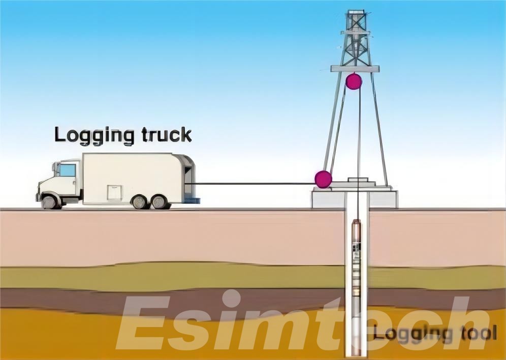
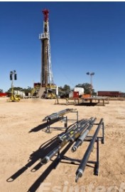
1. Wireline Logging
- Description: Wireline logging involves lowering specialized logging tools into the borehole on a cable (wireline) after drilling operations are completed.
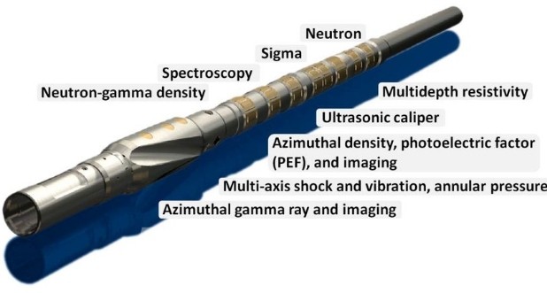
- Tools: Various logging tools are deployed, including gamma-ray, resistivity, neutron, density, and sonic tools.
- Measurements: Each tool measures specific properties of the formations, such as natural gamma radiation, electrical resistivity, neutron porosity, bulk density, and acoustic velocity.
- Applications: Wireline logging provides detailed information about lithology, porosity, permeability, fluid content, and mechanical properties of the subsurface formations. It is widely used for reservoir evaluation, geological interpretation, and wellbore integrity assessment.
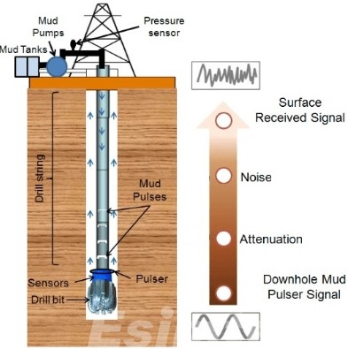
2. Logging While Drilling (LWD)
- Description: Logging While Drilling (LWD) involves integrating logging sensors and instruments into the bottom-hole assembly (BHA) of the drilling tool.
- Real-time Data: LWD tools acquire data in real-time while drilling, enabling continuous formation evaluation and decision-making at the rig site.
- Applications: LWD is commonly used for directional drilling, wellbore positioning, geosteering, and early reservoir evaluation. It provides immediate feedback on formation properties, allowing operators to adjust drilling parameters and optimize well placement.
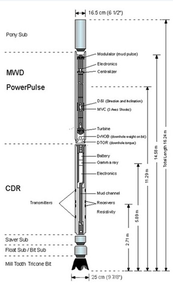
3. Measurement While Drilling (MWD)
- Description: Measurement While Drilling (MWD) is similar to LWD but focuses primarily on drilling parameters such as inclination, azimuth, and downhole pressure.
- Data Acquisition: MWD tools measure drilling parameters continuously while drilling, providing essential information for directional drilling and wellbore navigation.
- Applications: MWD is crucial for steering the drill bit accurately, maintaining well trajectory, and avoiding drilling hazards. It enables operators to drill complex well trajectories and reach target zones with precision.
4. Vertical Seismic Profiling (VSP)
- Description: Vertical Seismic Profiling (VSP) involves deploying seismic sources and receivers in a borehole to generate high-resolution seismic images of subsurface formations.
- Data Interpretation: VSP data is used to image the subsurface structure, identify reflectors, and delineate geological features.
- Applications: VSP is commonly used for reservoir characterization, seismic interpretation, and seismic monitoring. It provides valuable information about lithology, structural features, and seismic velocities, aiding in reservoir mapping and seismic inversion.
5. Cross-Dipole Sonic Logging
- Description: Cross-Dipole Sonic Logging measures the acoustic anisotropy of subsurface formations by transmitting and receiving shear waves in different directions.
- Data Interpretation: Cross-Dipole Sonic Logging provides information about formation stress, mechanical properties, and fracture orientation.
- Applications: Cross-Dipole Sonic Logging is used for geomechanical analysis, wellbore stability assessment, and hydraulic fracturing optimization. It helps identify natural fractures, stress directions, and mechanical properties of the formation.
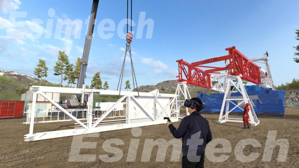
The Role of Simulation Technology in Advancing Geophysical Well Logging Practices
1. Tool Design and Optimization
- Virtual Prototyping: Well logging simulator allows engineers to create virtual prototypes of logging tools, simulating their physical design, operating conditions, and interactions with subsurface formations. This enables the optimization of tool geometry, sensor placement, and measurement configurations to improve data quality and reliability.
- Fluid Dynamics Simulation: Computational fluid dynamics (CFD) simulations are used to model the flow of drilling fluids and wellbore conditions during logging operations. By analyzing fluid dynamics, engineers can optimize mud circulation, minimize tool sticking, and enhance tool performance in challenging wellbore environments.
2. Subsurface Modeling
- Forward Modeling: Simulation software enables the creation of forward models that simulate the response of subsurface formations to logging measurements. By inputting parameters such as lithology, porosity, fluid content, and rock properties, researchers can predict the expected logging responses and compare them with actual field data for validation.
- Inverse Modeling: Inverse modeling techniques use logging data to infer subsurface properties by iteratively adjusting model parameters until the simulated responses match the observed data. This helps in reservoir characterization, fluid identification, and petrophysical analysis.
3. Data Interpretation and Analysis
- Well Log Simulation: Well logging simulation tools generate synthetic well logs based on geological models and logging tool responses. These synthetic logs serve as benchmarks for calibrating logging tools, validating interpretation techniques, and training personnel in log analysis.
- Machine Learning and Data Analytics: Simulation technology is integrated with machine learning algorithms and data analytics tools to automate data interpretation, identify patterns in logging data, and extract actionable insights. This enables faster decision-making and more accurate reservoir evaluation.
4. Training and Education
- Virtual Training Environments: Simulation technology creates virtual training environments where operators and geoscientists can practice logging operations, interpret data, and troubleshoot logging tool performance in a risk-free setting. This enhances training effectiveness, reduces operational errors, and improves logging efficiency.
- Educational Tools: Simulation software is used as educational tools in academic settings to teach students about geophysical principles, logging techniques, and subsurface modeling. These tools facilitate hands-on learning and enhance understanding of complex geophysical concepts.
5. Research and Development
- Exploratory Modeling: Simulation technology allows researchers to conduct exploratory modeling studies to investigate new logging techniques, sensor configurations, and measurement methodologies. This enables the development of innovative logging tools and techniques for improved subsurface characterization and resource exploration.
- Performance Evaluation: Simulation tools assess the performance of logging tools under various operating conditions, environmental factors, and formation properties. This helps in identifying potential limitations, optimizing tool performance, and guiding future research directions.
Conclusion
Geophysical well logging is a versatile and indispensable technique for obtaining valuable subsurface information in various industries and applications. By utilizing advanced logging tools methodologies and simulation technologies, geoscientists, engineers, and environmental professionals can gain insights into the Earth's subsurface, enabling informed decision-making, resource optimization, and environmental stewardship.